Category Archives: Precision Agriculture

Trans-Tasman Grower Day

Looking for answers - LandWISE 2015
Looking for answers – LandWISE 2015

What’s the Trans-Tasman Day about?

Given there are two dozen top Australian growers, agronomists and researchers joining us for our conference, arranging more time to discuss issues of interest was too good an opportunity to pass up.

The programme for the day is less structured than a normal conference day.  The morning is inside discussion, the afternoon getting out and about. But it does follow two days of conference, so we’ll be well primed.

We will spend time discussing some key crops – onions and potatoes included – and importantly technologies we can use to better understand and manage them.

We aim to identify areas of common interest and possible collaboration. What topics are relevant in both countries? What joint research opportunities are there? Where to from here?

After lunch we travel to a local farm, True Earth Organics, where Scott and Vicki Lawson and staff grow and pack a range of field, vegetable and berry crops. From there we go to a local major vegetable processing factory to view the next stage in the value chain.

Register here>

TrueEarthHeader

Excellent LandWISE 2016 Conference Speakers

We published the list and short biographies of our invited speakers today. We are again privileged to have an extremely knowledgeable group representing farmers, technologists and researchers from both sides of the Tasman Sea.

Conference keynotes and new LandWISE Australians include Ian Layden and Julie O’Halloran, precision horticulture researchers and extension specialists from the Queensland Department of Agriculture and Fisheries (DAF).

Ian and Julie are leading a group of two dozen top growers and agronomists for a week of related events built around the LandWISE Conference. Queensland farmer Ben Moore and Tasmanian farmer Robbie Tole will present their own experiences investigating precision horticulture opportunities.

Returning LandWISE Australians are Tristan Perez from Queensland University of Technology and John McPhee from the University of Tasmania. Tristan will update us on progress with weeding robot AgBot II and Harvey the capsicum picker. John will tell us about precision horticulture research underway in Tasmania.

Parallel work is being done in New Zealand. Look for reports from  Plant and Food researchers Sarah Sinton, Paul Johnstone and long serving LandWISE Board member Bruce Searle. Chris Smith from AgriOptics, Jane Adams of OnionsNZ and LandWISE’s Dan Bloomer and Justin Pishief will overlay a series of precision cropping and related topics.  Charles Merfield from the Future Farming Centre will give a review of biostimulants and related technologies – a different aspect of the agritech revolution.

Rounding out Day 1 are agritech accelerator Sprout Entrepreneur in Residence Stu Bradbury and two accelerating companies represented by Tom Rivett and Julian McCurdy.

Day 2 has a focus on value from data and robotics. We hear a lot about “big data” and “value chains”: what are they? Alistair Mowat, James Beech and Megan Cushnahan will tell us how they and others are getting real value, and where there’s still value to be tapped. Roger Williams will outline how Plant and Food is investing in digital horticulture research.

Lincoln Agritech’s Armin Werner has been a regular attendee at LandWISE. This year he takes the stage with a global review of field robotics and weeding technologies in particular. Kit Wong will tell us about Callaghan Innovation development of systems for machine vision to manage onion crops.

David Herries of Interpine will take us to a different sector and explain how UAVs are giving value in forest research and management.  And rounding it all up, Simon Morris of ALtus UAS will make sure we understand the regulations governing our use of this still new but very powerful technology.

So come to LandWISE 2016: the value of smart farming. Have you mind expanded, your knowledge updated and your excitement kindled. Mix and mingle with leaders in farming, agronomy and agtech!

Conference programme here>

Speaker biographies here>

Conference registration here>


The Value of Smart Farming

header1525 and 26 May 2016

Havelock North Function Centre

LandWISE 2016: The Value of Smart Farming is our 14th Annual Conference! Details are on-line and registrations open.

This year we are proud to host a delegation from Australia with two dozen growers and advisors crossing the Tasman to join us. The conference is the central point of their week long tour from Auckland through the Bay of Plenty to Hawke’s Bay and the Manawatu.

Tour leader, Ian Layden is also one of our keynote speakers. Ian and the Queensland growers have been trialing precision vegetable growing, assessing the same sort of things that are of interest to LandWISE members. We look forward to learning from their experiences.

A carrot harvester fitted with a yield monitor as part of Queensland Precision Vegetables research. (C) Image from SPAA 2015 Conference Proceedings

On a different angle, Charles Merfield will present results from a review of the agricultural uses of plant biostimulants. Plant biostimulants are diverse substances and microorganisms used to enhance plant growth. The global market for biostimulants is projected to increase 12 % per year and reach over $2 billion by 2018!  Despite the growing use of biostimulants in agriculture, many in the scientific community consider biostimulants to be lacking peer-reviewed scientific evaluation. Merf’s review will get us up to date with the science that is available on this topic of great and growing interest.

In 2015, LandWISE and Plant and Food Research began a three year project investigating variability in onions crops. We will report results from our first year’s activities, ranging from individual onion measurements to images from satellites and a swag of things in between.

Mapping canopy development with smartphone app - camera shrouded to avoid shadow effects
Mapping canopy development with smartphone app – camera shrouded to avoid shadow effects

We hear more and more about “big data” and “data analytics” and “value chains”.  These need not be scary! and we have several experienced speakers to let you in on the secrets. Join Alistair Mowat, James Beech and Megan Cushnahan as they explain value chains, the value of massive amounts of image data to identify signatures of specific crop factors, and how big data gives insights that were previously unseeable.

The party wouldn’t be complete without a peek at field robots and UAVs. Do you know the Civil Aviation rules about flying a drone – even on your own place?

Check out the programme, register and we’ll see you in Havelock North!

Thanks to Our Loyal Platinum Sponsors!

A visit to Climate Corporation

LandWISE’s Dan Bloomer joined a large group of New Zealand ag-tech organisations for a week getting to know the Silicon Valley venture capital and tech start-up scene.

The first visit was to Climate Corporation, recently acquired by Monsanto. How can you not be impressed by a three metre 3D projection screen? One you can control from a tablet, make it spin like the earth, view the globe from any angle, and project any theme you like.

ClimateCorpGlobe
Climate Corp Chief Technology Office, Mark Young, demonstrates the globe.

Climate Corporation seeks to understand the world and its climate, map it in real time and make useful information available to the world’s farmers. We saw time lapse of global cloud cover, near real time views of sea surface temperature and as shown above, global ground cover allocated to food for animals and food for people.

But their interest is wider than the weather. The Climate Corporation aims to build a digitized world where every farmer is able to optimize and flawlessly execute every decision on the farm.

They are investing heavily in agronomy and creating growth models to help predict crop development.   To achieve greater seed placement accuracy they developed SpeedTube, a precision elevator to replace drop tubes. This is said to allow more precise seed spacing at twice the normal planting speed. Same quality at twice the rate? Sounds attractive!

This visit was organised by Wharf42, NZTE, Callaghan Innovation and the Silicon Valley Forum.

Scouting by Consumer UAV

Consumer UAVs are increasingly seen as farm tools.  Some come with camera and packaged tech for easy flying, pretty much straight out of the box.

But before you leap in, please be aware there are RULES.

We suggest you spend time on the AirShare www.airshare.co.nz and CAA www.caa.govt.nz/rpas/ websites before you get started.  Designed specifically for UAV users they have easy to digest information setting out what you can and cannot do.

DJI Phantom 3

Our package came with all equipment, an extra battery and optional propeller guards packed in a tough custom carry case.  The camera is on a gimbal for steady shots, panning and tilting. Zoom in by getting closer!

A downloaded smartphone or tablet app shows flight information such as height, position and battery charge and lets you see exactly what the camera sees with no delay.

In windy conditions, we achieved about 13 minutes of flight time rather than the 23 minutes stated for each battery charge. Rules say you must be able to see the aircraft with your own eyes so you are probably limited to under 100ha. You could make a reasonable inspection in that time.

Peas and onions from 30m Web

We used the UAV to scout at the LandWISE MicroFarm. Viewed from 30m up, crop variation is immediately obvious.  Pea flowering striping seems to match drill widths. We had variable emergence too so ponder the link. Sprayer runs are visible too.

On the onion side we see thinner areas to the bottom right, and patches where Plant & Food have harvested sample plants as part of our joint OnionsNZ research project.

OnionsFrom40m_VerticalPlots

Viewed from directly overhead we see more of Plant & Food’s research plots, some harvested and some still being followed through to final harvest. The image indicates all these plots are within a reasonably good and even part of the crop.

To the bottom right, a lower wetter area shows lower populations where plants are smaller and fewer made it through establishment.

OnionsFromUAV_CloseUp45_web

Dropping to a metre of two above the crop and tilting the camera, we see up close. Because we are seeing what the camera is seeing, we can choose exactly what we want to check and go there immediately.

So we’ve scouted the whole paddock, had a closer look here and there, and if we need to, we can walk to the spots we want to check in detail. The thing is, we know where we should be looking.

Satellite Imagery

A large part of Heretaunga Plains horticulture was photographed for us by satellite at the end of November.

World View 2 satellite coverage of the Heretaunga Plains on 23 November 2105

Part of our OnionsNZ Variability project, the World View 2 coverage targeted our crop and other onion crops east of Hastings.

By capturing four bands of light, Blue, Green, Red and Near Infrared, we are able to get a “normal” colour image like an aerial photo, and a biomass map using the NDVI index.

The satellite image pixel size in 0.5m x 0.5m, so we get at least two pixels across each onion bed.

World View 2 NDVI image captured 23 november 2015 of MicroFarm onion and vining pea crops
World View 2 NDVI image captured 23 November 2015 of MicroFarm onion and vining pea crops

In the NDVI image, the onion crop is lower left paddock, the vining peas upper right. Red areas indicate low or no biomass, yellow light, green moderate and blue heavy cover. Note however that the value of each colour is slightly different for each crop.

Because the pea canopy is full ground cover while the onions are only roughly half ground cover, we had to use different value bands to see variation within each crop. If we used the same range, either the peas would all be blue, or the onions mostly yellow and red.

The striping effect in the onions is the onion beds. Some adjacent beds have quite different canopy densities.  The red edge around the onions is bare soil and light canopy in the outer beds. The blue area in the centre is influenced by charcoal from an old bonfire site. Even taking these things into account, there is a reasonably large amount of variation in this crop.

Red spots in the pea crop are patches with no plants. The red headlands show light canopy areas and the red strip centre right the irrigator access track. There are three different seed lines of Ashton peas making up the pea crop. These are not discernable in the satellite image. The crop was harvested on 14 December, and there was no significant difference seen in hand harvested plots or in the viner.

Fertiliser Calibration Resources Available

Development of procedures and resources for on-farm fertiliser spreader application checks have been completed. A trial workshop was run with farmers in Dunsandel and resources are available on-line.

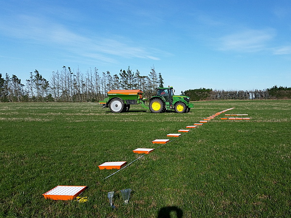
The emphasis of the project is ensuring the right amount of fertiliser is evenly spread. The rate is check by dividing the amount applied by the area covered. Determining evenness is trickier.

Like international systems and SpreadMark, pattern testing relies on sample collection in catch trays and mathematical analysis. A line of trays is laid across the path of travel, fertiliser collected and weighed, and data analysed.

Tray layout for a spreader pattern testTray layout for a spreader pattern test

To help the maths and reporting, an on-line calculator has been developed. This is publicly available at www.fertspread.nz.

The spreader test procedures will be presented at workshops at the FAR Waikato Arable Research Site on 10 December 2015, at Arable Y’s in Ashburton in April 2016. Other opportunities will be advised as confirmed.

More information and downloads available on the LandWISE website.

Onion variability Year 1

OnionsNZ

Enhancing the profitability and value of New Zealand onions

The purpose of this OnionsNZ MPI Sustainable Farming Fund research project is to provide the industry with tools to monitor and manage low yields and variability in onion yield and bulb quality.

In this collaboration with Plant & Food Research, LandWISE is providing precision agriculture paddock scale measurement and interpretation.

We have base maps from topography and surface ponding analysis completed by Page Bloomer Associates, and from AgriOptics Dual EM soil mapping. We also have some previous crop data including true colour, false colour and NDVI images of winter cover crops between successive onion crops in these paddocks. More details here>

We tracked crop development with a range of sensor technologies including AltusUAS MicaSense from UAV, Agricultural Software GroundCover app and some satellite imagery.

The collaboration with Plant & Food Research was to help us develop protocols to monitor crop development and yield variation (spatially and temporally). Linking these with crop modelling and agronomy helps determine why variation is occurring.

Crops were traced from paddock through harvest and storage so that post-harvest quality issues can be related to factors during growth. Linking paddock production to packhouse performance and back again may be key in unlocking value potential.

Grower led focus groups are involved in the project and analysis of results. They have a vital role in the development of practical tools they can use to monitor and quantify variability, to identify the causes of loss of yield and quality and share best practice to improve sustainability and grower returns.


New food production paradigms: why farm systems are changing


HBB_RSNZ_Header

A public lecture offered by the Hawke’s Bay Branch of the Royal Society of New Zealand

Dr Charles Merfield, Director
Future Farming Centre, Biological Husbandry Unit Lincoln

7:00pm – 8:30 pm, Wednesday 26th August 2015
Hawke’s Bay Holt Planetarium, Chambers St,  Napier

13032009338 smModern farming systems are 70 years old. They have been very successful at meeting their key aim; maximising food production. However, society is asking farmers to take on new aims including providing ecosystem services to protect and enhance the environment.

Four key technologies created modern farming: fossil fuels, synthetic nitrogen fertilisers, soluble lithospheric fertilisers and agrichemical pesticides. There are increasing issues with each of these both from the input (e.g. cost, resistance) and outcome (e.g. pollution) sides.

Sustainable agriculture is smart agriculture that uses all available tools to find long lasting alternatives. A key to developing and analysing farm systems is overlapping the sciences of physics, chemistry, biology and ecology. Sustainable farming can be viewed as a martial art, probing and testing the opponent’s strengths and weaknesses then using smarts, not brute force, to win the contest.

Viewing farming through the eye of Darwin’s Law of Evolution will allow more sustainable and durable solutions to be developed.

Charles MerfieldDr Charles Merfield is the founding head of the BHU Future Farming Centre which focuses on ‘old school’ agri/horticultural science and extension.

Charles studied commercial horticulture in the UK and then spent seven years managing organic vegetable farms in the UK and NZ.

In the mid 1990s he moved into research, focusing on sustainable agriculture including soil management, pest, disease and weed management general crop and pasture production.

He has been fortunate to work and experience agriculture in diverse range of countries including NZ, UK, Ireland, USA and Uruguay. He therefore has a broad knowledge of real-world farming as well as science as well a deep understanding of the history of agriculture and science, which enables him to paint the big-picture of where modern farming has come from and where it is going.

Thanks to the Foundation for Arable Research, Charles Merfield will also be offering one day workshops for farmers and industry.  For details see the FAR website>

FAR

Onion Research Underway

OnionsNZ

After months of planning our OnionsNZ, Plant and Food, Sustainable Farming Fund onion variability project, things are underway at the MicroFarm!

Gerry Steenkamer planted the crop on 2nd August. Rhinestone seed was donated by Vigour Seeds and treated for us by Seed and Field Services. We are very grateful for their support.

An initial residual herbicide application of Dacthal and Stomp was applied. We had a lot of wireweed last year and are keen to get on top of that.

PlantandFoodwebPlant and Food Research staff have established plots for detailed monitoring. They are doing many very detailed individual plant measurements at plot scale. LandWISE is coordinating a number of sensing surveys of the whole crop using a range of technologies.

20150805_PlotMarking
Plant and Food staff setting up monitoring plots in onions beds. (Wintery southerly)

More details for the research programme and measurements are available on the MicroFarm website.

Plant and Food researchers have developed growth models for a range of crops. This work will help refine their onion growth model, a key to understanding the development and variability in crops. The detailed plot measurements will also be compared with the whole paddock sensor measurements to corroborate and calibrate them.

The first paddock scale surveys have been completed. These give some base information and understanding of the site and it’s variability. Maps as pdfs are available on the MicroFarm website.

One of the first “layers” we can look at is Google Earth imagery – free info on the web! Have a look at your place: use the time slider to view a series of aerial and satellite images captured over recent and not so recent years.


MicroFarm Onion Beds with Winter Cover Crops (as shown on Google Earth image 19 April 2015)

We have posted some of “our place” images and some interpretation here>.

Pagebloomer vsPage Bloomer Associates completed an RTK-GPS survey using Trimble equipment from GPS Control Systems. The data were used to create surface ponding and runoff risk maps.

agriopticsAgriOptics completed a Dual-EM survey in early July. This gave shallow and deep soil information maps. The dry winter means soil had not reached field capacity when the survey was made, so we are a little cautious when interpreting the results. But we risked not getting a survey at all, and by planting in August it had still not rained.  With beds formed and crop planted and emerging, we have no opportunity now to repeat the survey.

AltusUAVAltusUAS has prepared NDVI maps of cover crops from UAV mounted sensors. They will be making repeated measurements as the crop develops. AltusUAS is now using MicaSense technology for efficient multispectral image collection.


ASL_Square_150ASL Software has provided their Cover Map canopy cover measurement tool fitted with high accuracy GPS. We can now use that technology to measure relative plant development and ensure our readings (our mapped data) are located in the correct beds!