Category Archives: Sensing

Robotic vision systems for real-time crop management

LandWISE 2015 Presenter – Cheryl McCarthy

Cheryl-McCarthyCheryl McCarthy is a researcher at the National Centre for Engineering in Agriculture, University of Southern Queensland based in Toowoomba.

As inputs costs continue to rise, on-farm productivity gains will come from greater sophistication in managing inputs like labour, water, chemicals and energy. Robotics is enabling the development of farming equipment and systems that can precisely sense and control to manage inputs and save labour.

NCEA is conducting a range of research projects that integrate autonomous sensing and control with on-farm operations, to robotically manage inputs within a crop. Major projects are being conducted in on-farm automation for weed spot spraying, adaptive control for irrigation optimisation, and remote crop surveillance using cameras and remotely piloted aircraft.

Cheryl is developing machine vision and sensing systems for agriculture. Machine vision-based weed detection systems have been developed for the sugar, cotton and pyrethrum industries. A Depth and Colour Segmentation process enables weed detection and a new processing technique enables the vision systems to operate at commercial ground speeds of 10-15 km/h.

Optimal irrigation strategies for overhead and surface irrigation systems are being investigated in projects for the cotton and horticultural industries. Trials in the cotton industry at sites on the Darling Downs and Central Queensland have demonstrated 10-30% water savings with 10% increase in yield, as well as labour savings, when using adaptive and automated irrigation systems which combine soil and crop monitoring sensors and variable rate applicators, together with software to calculate optimal irrigation amount.

Insufficient sampling for diseases or pests in crops and pastures can lead to misdiagnosis of the presence or level of infestation in a field, or uniform application of pesticide in a field where infestation is not distributed uniformly. Similarly, field conditions, including crop growth, water stress and weed coverage, vary spatially and require frequent monitoring to optimise management.

NCEA is developing technology that will couple rapid, field-scale data collection from RPAS with automated data and image analysis to automatically diagnose unhealthy areas of crop (see below).

3D model of cotton crop generated by RPAS and photogrammetry software

Aerial Mapping at the MicroFarm

Centre for Land and Water residents, AltusUAS are creating detailed farm and crop maps of the LandWISE MicroFarm.

Altus Unmanned Aerial Solutions specialises in the manufacture of professional UAS systems for wide-ranging applications. They build and operate systems of high specification with features including built in redundancy, custom control interfaces and integrated emergency parachute. They offer platforms with class leading flight performance as well as all-weather capabilities.

AltusMissionNDVI
An AltusUAS Quadcopter sets off on a mission to map the MicroFarm

Even a simple aerial image is highly informative – the view from above changes perception immensely!

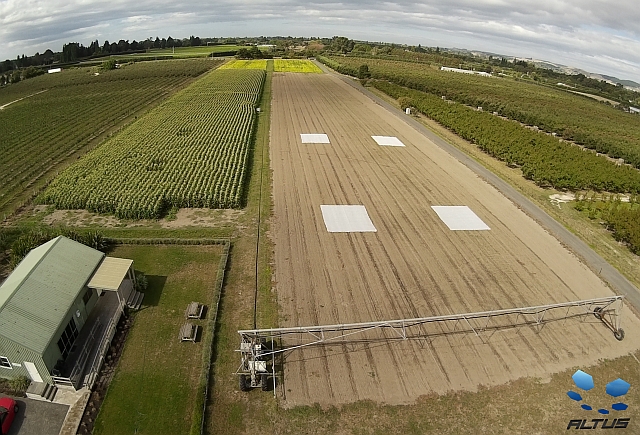
MicroFarm fields and Green Shed meeting venue - image captured by AltusUAS
MicroFarm fields and Green Shed meeting venue – image captured by AltusUAS

At the MicroFarm, they are using their technologies to survey the site, photogrammetry to process imagery and further analysis to create a 3D model of the MicroFarm and crops.

A composite image created from many overlapped photographs taken from a GPS guided UAV - the basis for a 3D MicroFarm model
A composite image created from many overlapped photographs taken from a GPS guided UAV – the basis for a 3D MicroFarm model
A zoom-in on part of the image showing the Green Shed and corner of a crop of mustard


View a flythough of the model (it looks like a video of the site) on YouTube here>

AltusMicroFarmVideoImage

As well as terrain models/topographic maps, they can produce detailed NDVI information.

We are using this information to understand our site in much more detail. With individual pixels as small as about 4cm, we can zoom in practically to individual leaf scale. Do we need that? Not for many applications, but it does raise new possibilities around pest and disease identification and definitely enable us to view individual plants.

To receive updates sign-up for the LandWISE E-newsletter and follow @LandWISENZ on Twitter (see the right sidebar).

The Farm of 2030

The 2015 LandWISE Annual Conference attracted record numbers. It’s theme looked forward 15 years to contemplate what a farm might look like in 2030.

We are most grateful for the strong support of our many sponsors, a vital feature for bringing such events to the community.Sponsor_Sheet_600


You can see the full programme here>

RobertFitch2 TristanPerez1 Cheryl-McCarthy

Three speakers, Robert Fitch, Tristan Perez and Cheryl McCarthy, travelled from Australia to help lead discussions.

Tom Botterill PeterSchaare Ian Yule

Add Tom Botterill, Peter Schaare and Ian Yule

GertHattingh John Ahearn JohnChapman

Gert Hattingh, John Ahearn and John Chapman

BruceSearle200 FinlaysonChristina_200x200 geoff-low-res-e1423206134526

Bruce Searle, Christine Finlayson and Geoff Bates plus others from New Zealand and see the wealth of knowledge and experience available.

You can see all speakers and their biographies here>

On Day 1, presenters discussed sensing, control and robotics. Developments in this area are proceeding remarkably fast, with prototype machines finding their own way around farms, identifying weeds by species and applying custom treatments including sprays only to leaves. Additional presentations on pasture and plant quality detection, grapevine pruning and fruit quality analysis made it a full informative day.

At the end of the day, delegates formed small teams to design their dream agricultural robots – an excellent way to consolidate information. The key however, was identifying what their robots should do (not how) and describing the constraints under which it would need to operate.

As soon as you state a “how” you limit the options that can be considered in determining the final design. Maybe it shouldn’t be a 4-wheeled rover, but an aerial vehicle, or even a ground crawler. Get the specifications right, and the design will identify itself.

AgBot - image from Queensland University of Technology
AgBot – image from Queensland University of Technology

Day 2 began with discussions around variability. Identifying what variability exists, where it is and whether it justifies custom management is a critical starting place. Speakers also focused on managing two important farm  inputs to ensure the right job is done – seed placement and fertiliser application.

Day 2 was completed at the LandWISE MicroFarm at the Centre for Land and Water. There were demonstrations of in-field nitrogen testing, a soil pit to examine, a robot pulling a urine patch detector, a one pass strip-till and planting machine, testing fertiliser spreaders and UAVs.

AltusMissionNDVI
An AltusUAS UAV takes off at the Centre for Land and Water, a mission to collect data at the LandWISE MicroFarm

Something for every forward thinking agriculturist!

More on-line here>


Design-a-Bot Workshop

New at LandWISE Conference 2015 was a special session where small groups have a chance to specify their “dream farm robot”.

Mammoth Robot - a reconfigurable robot for row crop monitoring (University of Sydney image)
Mammoth Robot – a reconfigurable robot for row crop monitoring (University of Sydney image)

The point of the Design-a-Bot workshop session was to fully explore things farmers would like automation to assist and where they perceive value will be created. Along with that, it was a great way to ensure our understanding of the sensing, automation and associated technologies was on-track. 

A number of world leading researchers in these fields were presenters at “The Farm of 2030” and others attended as delegates.  They will circulated around the design teams, listening, learning and offering their combined wisdom.

The key was not knowing how to make it work. Specification means knowing what you want it to do and the constraints under which it must operate. Starting to think about how before you know exactly what can severely restrict the creative thinking that ultimately identifies the optimal designs to achieve your dreams.

Callaghan Innovation Technical Session Filling Rapidly

A high level of interest from lead researchers, farmers and technical people has seen available places at the Callaghan Innovation Special Technical Session fill rapidly.

Numbers were limited because of space, and to aid high quality interaction between participants. Why are people wanting to come?

My reason for wanting to be part of this meeting is to upskill, to share ideas

I’m interested to help link researchers and ag industry people, and to hear about ag industry needs for research, around some specific projects we are looking at and also in general, to help bring researchers and industry together

To look for initiatives for the application of UAV technology.  To better understand the challenges and opportunities facing the precision ag industry

To share with others a vision of how technology will lead food production in the future

 I am significantly involved in the emerging and evolving technologies for NZ agriculture/horticulture industries. The networking and discussion on this day will be of immediate interest/benefit to me and I am in a position to contribute meaningfully to the day from a research but also from the perspective of the farmers I interact with on a daily basis discussing developments in this area.

MicroFarm Update March 2015

MicroFarm happenings are updated on Twitter @LandWISENZ with tweets appearing on both the LandWISE main website and the MicroFarm specific site.

The aerial view above of the MicroFarm was provided by new Centre for Land and Water residents, AltusUAS. This is a wide angle colour image, but we are also looking forward to capturing a range of other image types over coming weeks.

So far this season we have completed fourteen irrigation rotations across our various crops. We have guidance from HydroServices soil moisture monitoring and advice. Their weekly reports are posted on the MicroFarm Irrigation Monitoring page.

The linear-move irrigator that the Ritchie family  provided has been critical to success this year – one of the driest we’ve seen for a while. In August we posted a story about rebuilding the linear from parts.

Now, part way through Cyclone Pam, Hawke’s Bay is getting much needed rain. In our case, this has been a manageable amount and we have been fortunate to avoid the strong winds that have caused trouble north of us.

Since last week we’ve received regular showers, with daily rain totals of 20mm, 10mm, 0mm, 5mm and 25mm and moderate rain continuing. So 75mm so far, with about 12mm ET in that time. You can access our weather data from the MicroFarm site weather page, provided for us by HortPlus MetWatch.

Cover crops planted last month are coming away well. We irrigated them to get them started, but with the current rain, that is probably it for the season. The mustard and the oat/vetch mix were both direct drilled by Mike Kettle Contracting.

Our two crops awaiting harvest are sweetcorn for McCain Foods and navy beans for Heinz-Watties. Both crops are looking good.

Looking at the AltusUAS image above, the gaps in the sweetcorn on the left are where crop samples were taken to compare growth of seedlings with and without cover.

At the far end of the MicroFarm, the navy beans glow yellow as they reach maturity. Despite the colour change, HydroServices soil moisture monitoring shows water use has remained high, suggesting plants remain active.

The four white squares in the paddocks on the right are cover cloth on our cover crops: mustard and on an oat/vetch blend. We will remove two covers soon and monitor growth. Two other covers will remain in place for a few more weeks.

We are keen to involve even more technology partners at the MicroFarm.

Wintec has established a trial network of soil moisture sensors which are being compared with the HydroServices neutron probe results.

Installing the WINTEC wireless soil moisture sensor array

CoverMapOnionsASL software, (LandWISE Yield Estimation software) and apps for pipfruit and irrigation industries) have developed a ground cover measurement tool. We used it to map MicroFarm onion crop canopies and found good correlation with final yields.

If you have something to test or demonstrate, or know someone that might add value, let us know!

Remember, you can follow @LandWISENZ on Twitter, or keep an eye on the MicroFarm website for the most up to date information on happenings.

MicroFarm News: Dec 2014

Recent postings on the MicroFarm Website

To December 2014

20141114_165126_web

Monitoring Variability in Peas

Peas are one crop that has huge variation. It’s hard to know if the crop will yield four tonnes per hectare or twelve. Even within small sampling plots we measured yields less than 4 t/ha and greater than 13 t/ha. More>

20141128_103522-web

Monitoring Variability in Onions

Our first MicroFarm onion crop is extremely variable. We want to measure variability so we can better assess it. If we can measure objectively we can make better decisions. We are interested in spatial variability and temporal variability. More>

Getting above the crop

LandWISE Conference Presentation -Trimble’s UX5

UX5

The UX5 is Trimble’s new Unmanned Aircraft System (UAS) for aerial mapping and imaging. It can cover 200ha an hour, getting 5cm pixel resolution images used to generate 3D images of the terrain. Farmers can determine crop heights and generate topographic maps and models for land levelling and drainage applications.

The UX5’s camera captures near infrared to allow vegetation index calculations to enhance crop scouting and helps detect pests, diseases and nutrient issues. The image resolution means considerable detail can be seen giving agronomists a tool to see parts of plants.

We have been watching development in the UAS/UAV/drone space and see these machines as one of the next leaps in agricultural technology. We note the aircraft is only one part of a complex puzzle. The camera is another and GPS referencing yet another.

But it is turning data into farm management information that gives the value so the analysis software and knowledge of how to get benefits from these new tools are the critical aspect to us. And we always want to know how a new product integrates with the other tools in use on the farm. With spatial data that means the farm map, the tractor, the planter, the fertiliser spreader, the harvester and everything else too!

The UX5 will be presented at LandWISE 2014 and delegates will get to see it in the flesh. We are very interested to know how farmers and their support crew perceive it, what they think its first uses might be.  This will be a great opportunity to seek more clarification.

Here’s a link to whet your appetite http://www.youtube.com/watch?v=tuzh9XCIins