Ian Yule, Centre for Precision Agriculture, Massey University
A presentation by Ian Yule, Reddy Pullanagari, Gabor Kereszturi, Matt Irwin, Ina Draganova, Pip McVeagh, Tommy Cushnahan, Eduardo Sandoval.
Remote sensing methods are becoming much more accessible for end users in terms of access to results and the method in which they are presented. They can be developed into systems for herbage analysis which will measure every square meter of a farm or river catchment and publish the results in the form of a map, as below, rather than complex hyperspectral analytical measurements.
The team at Massey University have been using a hyperspectral imaging tool called Fenix. It is flown in an aircraft usually at around 500-800 m above ground level and has been used to measure hill country properties within New Zealand in the first instance. The map below shows the level of ME in pasture for an example scene, but the major nutrients can also be mapped in this way.
The catalyst for purchasing the sensor was the Ravensdown/ MPI, funded PGP project; Pioneering to Precision: Fertiliser Application to Hill Country.
The first scientific objective of the project is to map the nutrient concentration of pasture over hill country properties. The business objective is to provide much better information around the productivity of hill country in order to calculate the fertiliser requirements more accurately and improve the overall utilisation of nutrients.
Previous work indicated that significant financial benefit could be achieved from this approach. This is the first time that an imaging tool has been used and this is important because it overcomes many of the difficulties of on-the- ground sampling and then using these samples to represent the whole farm. It is basically impossible to capture the true variability of these properties from ground sampling.
The sensor detects light in the Visible (VIS), Near Infrared (NIR) and short wave infrared (SWIR) parts of the electromagnetic spectrum. This gives it the ability to determine the bio-chemical properties of vegetation that it observes. It has been shown to be a very robust technology for laboratory analysis and this new development takes it out of the laboratory and in the field.
The images captured in strips are mosaiced together in order to develop a single image for the whole area. Each pixel has 448 different layers of information, corresponding to 448 different wavebands which make up the spectral signature for each pixel. It is by comparing the spectral signature using a number of statistical techniques that the nutrient concentration within the vegetation can be identified.
The big advantages with this approach are that the results can be presented in the form of a map, information can be produced quickly with limited need for laboratory based chemical analysis. All of the complex statistical and analysis processes have happened in the background and the results can be presented with in a Geographical Information System (GIS). In a GIS environment data can be linked to decision making software which will help farmers decide on the optimal fertiliser policy for the farm.
Acknowledgement. The image was produced from a survey from the PGP Project, Pioneering to Precision: Fertiliser application in hill country, which is funded by Ravensdown Fertiliser Cooperative and the Ministry for Primary Industries MPI.
New Zealand Centre for Precision Agriculture, Massey University, Institute of Agriculture and Environment. Palmerston North, New Zealand.
The Oekosem Strip Tiller is a Swiss product manufactured by Baertschi. Nick Gillot says it’s all about creating an optimal seedbed in rows, minimizing soil erosion and operating costs and simultaneously securing earnings over the long term.
Nick says the metering unit is a major component of the Monosem planter. With the new NG Plus 4 model, Monosem has conserved the the best of the NG Plus units and has added the operating comfort. Nick says adjustments are made easier so the planter can be perfectly adjusted to conditions to get optimal planting.
The machine was operating at the LandWISE MicroFarm Field Session on Day 2 of the Conference. The area put aside for the demonstration was in long term grass that had not been sprayed out – it was a good test.
Gert’s current work involves finding ways to build more sustainable and energy efficient homes, finding better ways for the normal household to live sustainably, and evaluating new technologies.
Gert says the most burning question in any business venture is whether your actions will cost you money, or make you money. Any decision you make in the production, marketing or operational sphere has an influence on this statement. This paradigm has been a design key since Wintec have ventured into producing cost effective sensor arrays and wireless networks.
In the modern measurement world, there are three cost drivers – quality of the sensor(s), the cost of the network carrying the data, and the cost of making sense of and using the data.
Gert and colleagues started off by looking at the network and the data carrier first, and designed a generic sensor module to host and manage almost any sensor type. They also developed a database model that would host any data from sensors, as well as the encryption and data quality protocols.
To date, their system can host the following type of sensors: GPS, Air Humidity, Air Temperature (2 sensors), Air pressure, solar irradiation, wind speed, wind direction, soil moisture (various sensors), pH, conductivity, dissolved oxygen, oxidation-reduction potential, ammonia, CO2, methane, propane, NOX and some alcohols.
A single sensor module can carry at most thirteen sensors, with a practical thirty sensor modules per network. This totals to 390 sensors per network.
This technology is being trialed at the LandWISE MicroFarm, gathering, transmitting and processing soil moisture information from an array of sensors.
John Chapman is the Product Specialist for seeding and cultivation equipment at Power Farming.
John spent 15 years managing farms in Suffolk and Norfolk in the UK after graduating with an MSc in Farm Management.
His experience with rotations involving many different crops involved many cultivation techniques, as well as a wide range of cultivators and drills to achieve quality seed beds and successful crop establishment in all sorts of conditions and soil types.
Success from precision planting does not come from one or two well made decisions but from a whole host of factors that come together to produce a successful crop.
It is critical to check all areas where the seed drops from to the point where it hits the ground that there are no points at which the seed may catch or have its trajectory affected.
Ensure that seed plates are clean and free from any grooving that has occurred. Badly grooved seed plates have the potential to be distorted and loose vacuum. The seed needs to be of the optimum quality to singulate well. Even size and condition is essential. Seed size directly relates to the seed plate chosen.
Forward speed is where in most cases the wheels fall off the wagon. Forward speed has a direct correlation to spacing through the planter’s ability to cope with the speed.
Although drilling depth is of vital importance for even seed germination and emergence it will be affected by the soil conditions, forward speed, varying conditions across the paddock and the state of the coulters.
Centre for Land and Water residents, AltusUAS are creating detailed farm and crop maps of the LandWISE MicroFarm.
Altus Unmanned Aerial Solutions specialises in the manufacture of professional UAS systems for wide-ranging applications. They build and operate systems of high specification with features including built in redundancy, custom control interfaces and integrated emergency parachute. They offer platforms with class leading flight performance as well as all-weather capabilities.
An AltusUAS Quadcopter sets off on a mission to map the MicroFarm
Even a simple aerial image is highly informative – the view from above changes perception immensely!
MicroFarm fields and Green Shed meeting venue – image captured by AltusUAS
At the MicroFarm, they are using their technologies to survey the site, photogrammetry to process imagery and further analysis to create a 3D model of the MicroFarm and crops.
A composite image created from many overlapped photographs taken from a GPS guided UAV – the basis for a 3D MicroFarm modelA zoom-in on part of the image showing the Green Shed and corner of a crop of mustard
View a flythough of the model (it looks like a video of the site) on YouTube here>
As well as terrain models/topographic maps, they can produce detailed NDVI information.
We are using this information to understand our site in much more detail. With individual pixels as small as about 4cm, we can zoom in practically to individual leaf scale. Do we need that? Not for many applications, but it does raise new possibilities around pest and disease identification and definitely enable us to view individual plants.
On Day 1, presenters discussed sensing, control and robotics. Developments in this area are proceeding remarkably fast, with prototype machines finding their own way around farms, identifying weeds by species and applying custom treatments including sprays only to leaves. Additional presentations on pasture and plant quality detection, grapevine pruning and fruit quality analysis made it a full informative day.
At the end of the day, delegates formed small teams to design their dream agricultural robots – an excellent way to consolidate information. The key however, was identifying what their robots should do (not how) and describing the constraints under which it would need to operate.
As soon as you state a “how” you limit the options that can be considered in determining the final design. Maybe it shouldn’t be a 4-wheeled rover, but an aerial vehicle, or even a ground crawler. Get the specifications right, and the design will identify itself.
AgBot – image from Queensland University of Technology
Day 2 began with discussions around variability. Identifying what variability exists, where it is and whether it justifies custom management is a critical starting place. Speakers also focused on managing two important farm inputs to ensure the right job is done – seed placement and fertiliser application.
Day 2 was completed at the LandWISE MicroFarm at the Centre for Land and Water. There were demonstrations of in-field nitrogen testing, a soil pit to examine, a robot pulling a urine patch detector, a one pass strip-till and planting machine, testing fertiliser spreaders and UAVs.
An AltusUAS UAV takes off at the Centre for Land and Water, a mission to collect data at the LandWISE MicroFarm
Something for every forward thinking agriculturist!
The aerial view above of the MicroFarm was provided by new Centre for Land and Water residents, AltusUAS. This is a wide angle colour image, but we are also looking forward to capturing a range of other image types over coming weeks.
So far this season we have completed fourteen irrigation rotations across our various crops. We have guidance from HydroServices soil moisture monitoring and advice. Their weekly reports are posted on the MicroFarm Irrigation Monitoring page.
The linear-move irrigator that the Ritchie family provided has been critical to success this year – one of the driest we’ve seen for a while. In August we posted a story about rebuilding the linear from parts.
Now, part way through Cyclone Pam, Hawke’s Bay is getting much needed rain. In our case, this has been a manageable amount and we have been fortunate to avoid the strong winds that have caused trouble north of us.
Since last week we’ve received regular showers, with daily rain totals of 20mm, 10mm, 0mm, 5mm and 25mm and moderate rain continuing. So 75mm so far, with about 12mm ET in that time. You can access our weather data from the MicroFarm site weather page, provided for us by HortPlus MetWatch.
Cover crops planted last month are coming away well. We irrigated them to get them started, but with the current rain, that is probably it for the season. The mustard and the oat/vetch mix were both direct drilled by Mike Kettle Contracting.
Our two crops awaiting harvest are sweetcorn for McCain Foods and navy beans for Heinz-Watties. Both crops are looking good.
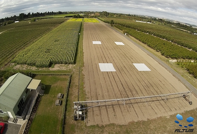
Looking at the AltusUAS image above, the gaps in the sweetcorn on the left are where crop samples were taken to compare growth of seedlings with and without cover.
At the far end of the MicroFarm, the navy beans glow yellow as they reach maturity. Despite the colour change, HydroServices soil moisture monitoring shows water use has remained high, suggesting plants remain active.
The four white squares in the paddocks on the right are cover cloth on our cover crops: mustard and on an oat/vetch blend. We will remove two covers soon and monitor growth. Two other covers will remain in place for a few more weeks.
We are keen to involve even more technology partners at the MicroFarm.
Wintec has established a trial network of soil moisture sensors which are being compared with the HydroServices neutron probe results.
Installing the WINTEC wireless soil moisture sensor array
ASL software, (LandWISE Yield Estimation software) and apps for pipfruit and irrigation industries) have developed a ground cover measurement tool. We used it to map MicroFarm onion crop canopies and found good correlation with final yields.
If you have something to test or demonstrate, or know someone that might add value, let us know!
Remember, you can follow @LandWISENZ on Twitter, or keep an eye on the MicroFarm website for the most up to date information on happenings.
The Food and Agricultural Organisation FAO “International Year of Soils” is now well under way. We are looking to do our part in raising awareness and welcome ideas for activities and actions.
Hawke’s Bay Regional Council is a Platinum Sponsor of our annual conference, recognising the importance of soils to our region. We will have a soil health component at the Field Sessions.
The LandWISE MicroFarm is also looking at how we might help soil help us. Following our onion crop, we direct drilled cover crops.
Cover crops being direct drilled into old onion beds by Mike Kettle Contractors
The crops themselves, Caliente Mustard in one half and an oat/vetch combination in the other, are intended to aid soil health, adding biomass and structural quality. The mustard will need to be incorporated to provide soil fumigant activity before the next crop. But we anticipate positive nett benefit to our soil.
Peas are one crop that has huge variation. It’s hard to know if the crop will yield four tonnes per hectare or twelve. Even within small sampling plots we measured yields less than 4 t/ha and greater than 13 t/ha. More>
Our first MicroFarm onion crop is extremely variable. We want to measure variability so we can better assess it. If we can measure objectively we can make better decisions. We are interested in spatial variability and temporal variability. More>
Queensland University of Technology is investigating robotic technologies as a new generation of tools for site-specific crop and weed management. Tristan Perez described “AgBot”, a platform currently being manufactured to a design by QUT. AgBot is 2m long, 3m (adjustable) wide and 1.4m high.
AgBot – image from Queensland University of Technology
Tristan suggests the use of a swarm of small light robots, that operate at lower speeds and have a suit of sensor-acting devices, could lead to a better application of agrochemicals. He also sees them having a key role addressing herbicide resistance as they could enable use of mechanical or microwave weed destruction techniques.
Now we have your attention:
LandWISE’s Dan Bloomer attended the 17th Precision Agriculture Symposia of Australasia in Adelaide. This event is a collaboration between SPAA and the University of Sydney, bringing together researchers and practitioners with the aim of promoting the development of PA to profit agricultural production.
The Symposium has a broad coverage including new technologies, big data, precision cropping and viticulture and spatially enabled livestock management.
As well as an excellent range of speakers, the symposium is a very good networking opportunity for people active in this space. There is a close alignment with LandWISE interests and the supporting Trade Displays were very relevant and informative
A few notes about some of the other presentations:
Lucas Haag, Professor at Kansas Sate University and Partner and agronomist in his family’s large farming operation, described the evolution of PA in the dryland environment of the US High Plains. While a very different context to New Zealand agriculture, the lessons appear readily transferable.
He noted the critical role of autosteer, rather than yield mapping, in accelerating the adoption of precision agriculture tools among a wide spread of cropping farmers, and the subsequent search by those farmers to gain additional return on that significant investment. This is a pattern very familiar to us.
A take home message from Lucas was the use of PA technologies to make better whole field or whole farm analysis and decisions. While they use PA tools to help evaluate new varieties, seed treatments and other new product options, machinery management decisions have added considerable value to their business.
Examples included evaluating the economics of grain stripper versus conventional header harvesting, grain cart logistics and the value of a dedicated tender truck to support spraying operations – all applications that were not anticipated. Better telematics and machine monitoring technologies and costs of machinery suggest this will continue to be an area of focus.
As manufacturers have increased claims of spreading width, and farmers and contractors have increased bout widths accordingly, arable farmers have noted increased striping and lodging in crops where blended fertilisers are applied. The Massey studies identify the different ballistic properties of blend components, and the increased bout widths, explain these symptoms.
A number of presentations included reference to UAV technologies. Some are very sophisticated and used to carry very high-spec sensors. Some are just used to get up above the crop for a new perspective. Regardless, the potential benefits are clear and the price dropping and capability rapidly rising.
Luke Schelosky of RoboFlight Australia their approach using either piloted or unpiloted aerial vehicles to capture ultra-high resolution imagery create 2 cm resolution maps. As we have seen before, the key to the technology is the processing software rather than the choice of vehicle.
Miles Grafton also reported Massey work using remote sensing for pasture management. They use a number of Remote Piloted Aerial Systems (RPAS) including multi-rotor (e.g. QuadCopter) and fixed wing (e.g. Trimble UX5) as well as a range of multi- and hyper-spectral sensors and imaging systems. While at an early stage, Massey research is showing promise in remotely sensing pasture quantity and quality, including assessing pasture nutrient levels.
Lucas Haag also discussed the role of UAVs, suggesting three unique features create special potential:
Temporal Resolution -The data are fresh, not from the last cloud free satellite pass
Spatial Resolution – the user can control flight height and pattern to gain the redolution needed for the intended use of the data
A separate step – because it requires a separate trip to the field, there is opportunity to add external knowledge before inputs are applied. This allows, for example, adding historical yield monitor knowledge (and perhaps knowledge of herbicide mistakes) to UAV NDVI imagery when creating a Nitrogen application map.
Lucas further addressed spatial and temporal variability measures determined from Yield Maps, contrasting Normalised Yield and Yield Stability. Multi-year Normalised Yield provides the measure of Spatial Variability or spatial yield potential, and the standard deviation (defined perhaps as stable high, stable low and unstable yield) provides a measure of temporal (over time) variability.
Cheryl McCarthy presented crop sensing and weed detection work being undertaken at the National Centre for Engineering in Agriculture at the University of Southern Queensland. Colour and depth image analysis is enabling them to identify weeds in real time, and spot spray them at 10 – 15 km/h. Interesting to note this requires analysis of 30 images per second, as at least three image frames per plant are needed for sufficient confidence.
Two Trade Displays that caught attention were SST Software and PA Source; both aimed at helping farmers and their advisors access the benefits of Precision Agriculture.
Mark Pawsey demonstrated SST Software’s Sirrus programme, a cloud based data access, storage and analysis package. Of additional interest was their decision to open their agX Platformto other developers creating supplementary apps. This reflects the opening also of the John Deere platform and similar moves by other organisations.
Ben Jones of PA Source spoke at LandWISE in 2012 and has facilitated our use of that platform for supply and analysis of spatial data including yield maps, EM maps and satellite data. New offerings include www.watch.farm and www.pastack.com.
Watch.farm delivers Landsat satellite sourced vigour maps to your email every 16 days (cloud cover permitting). Part of the watch.farm package includes change maps, so you can track growth change in individual paddocks. We want to try this service in the current summer season and see it having a significant role to play if the resolution coverage is satisfactory in the “Land of the Long White Cloud”.
PAStack also uses Landsat imagery, “stacking” images from as far back as 1999 to 2013 to see which areas provide more or less biomass and how consistent they are. We will also investigate this product as there appear to be a number of uses of potential benefit to LandWISE farmers and their supporters.


 John Chapman is the Product Specialist for seeding and cultivation equipment at


 ASL software, (LandWISE Yield Estimation software) and apps for pipfruit and irrigation industries) have developed a ground cover measurement tool. We used it to map MicroFarm onion crop canopies and found good correlation with final yields.


